3D-Visualization and 3D-Animation of satellite
images and maps
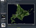
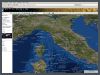
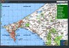
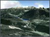
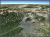
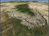
With the combination of satellite images
or maps and digital elevation models it is possible to generate fascinating
and photorealistic 3D-scenes.
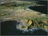
We can use our several terabytes large archive of satellite imagery
and height data to generate high-end 3D-visualizations and animations
for any place in the world. On demand we organize also more up-to-date-scenes
or scenes with highest resolution.
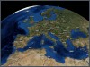
We deliver high-quality, seamless and continuous fly-over and zoom-in-animations
from any location on earth.
3D Animations
Use our 3D-Geobrowser Atlo3D to create 3D Fly-Throug Animations of the Earth. Activate the "Animation Tool" and add keyframes and see the real-time preview of your animation sketch. Send us your animation and we will render a smooth high definition video file for you.
Specifications
• 3D-visualization of satellite imagery, maps and vector data
• 3D-animations in Flash- or Videoformat in PAL, NTSC or HDTV quality
• 3D-images also in extrem high resolution for e.g. large scale printing
Use cases
• Television (edu- und infotainment, sport-events, weather forecast,
etc.)
• Scientific visualization
• Print media, press
• Web design
• Poster / Banner prints